We’ve been on the road since mid-July, taking full advantage of our transition time between Cambridge and Aix, so I haven’t written in a while (I intend to pick up again in earnest once we arrive at our house in Provence). In the meantime, we spent a week in Maine not far from Acadia National Park, a week in Yvoire, France, and a week in Wengen, Switzerland.
I don’t really have too much to say about Maine, other than that it’s great and you should go there, especially if you can stay in a coastal village or canoe along a north-country river.
Yvoire was sunny, charming, and fun, a walled medieval village on the shore of Lake Geneva. It was the perfect welcome to Europe. I don’t think I’ll say more about it here for now, although feel free to see some of our pictures here.
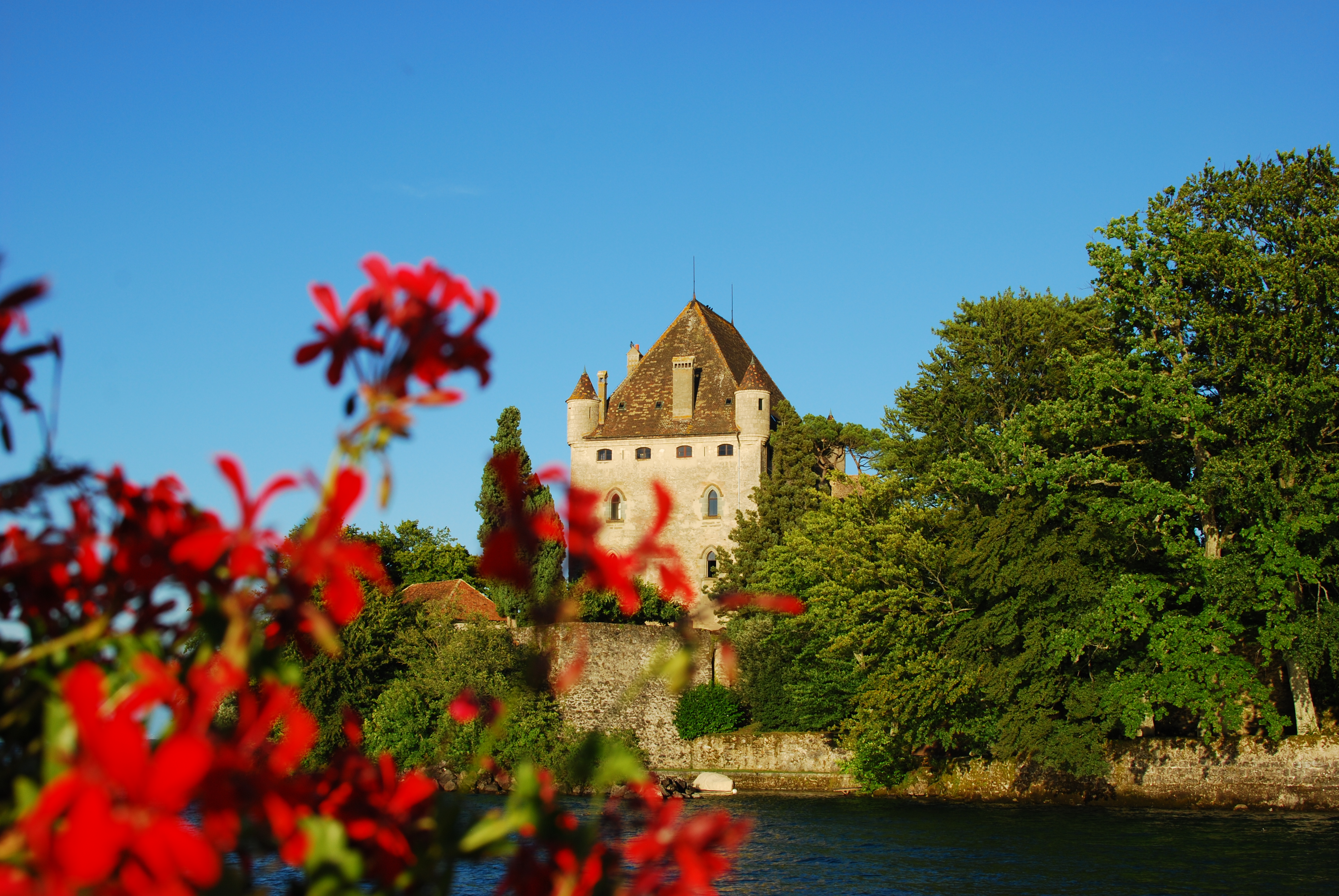
Two notable features about Yvoire: its castle is still inhabited by the Baron d’Yvoire’s family and it’s a winner of the grand prix de fleurs en France.
Actually, here’s one observation about getting to and from Yvoire that surprised us and would probably surprise other border-security conscious Americans: going between France and Switzerland is like going between Massachusetts and Vermont. No border security, no guards, no nothing, just a shuttered checkpoint that looked like it was slated for removal. I know, I know, this is the E.U. and not really at all comparable to the U.S. and its neighbors, but hold on — Switzerland is not in the E.U., so… I’d say that maybe Switzerland is more relaxed than the U.S. but that is definitely not the case (this is a place where the trains run on time, remember). It’s a mystery.
Ed. note: Mystery solved via wikipedia. Since 2009, Switzerland has been part of the Schengen Treaty. Not the most famous treaty for Americans, but important because it involves removing checks at border crossings between member countries (Belgium, France, Germany, Luxembourg, Netherlands, Norway, Iceland, Switzerland, Italy, Spain… the list goes on).
Onto our week in Wengen, a mountain town in Switzerland. I’ll say something about that because I think I have something to say about mountain towns. For an Easterner, I’ve spent a lot of time in mountain towns — in New Mexico, Colorado, California, Washington, a little Arizona… does North Conway, New Hampshire count? Following are a few things that stood out.
Trains Go Everywhere.
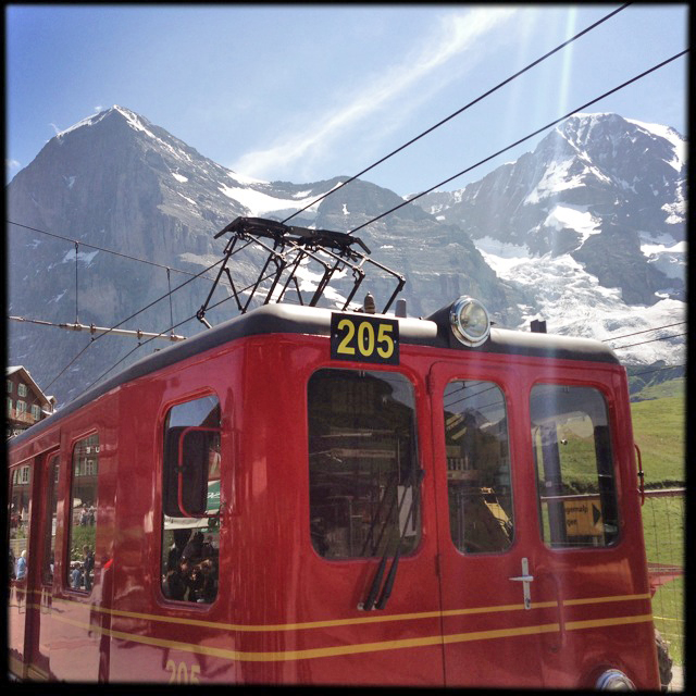
Train between Wengen and Kleine Scheidegg
Just a few weeks ago, we were in Maine and visited the top of Cadillac Mountain in Acadia National Park. On a clear day, which it was, you get the most amazing views of islands, forest, and sea. It’s worth the trip. But bear in mind that, Acadia being like other parks in America, car access is a priority, and you wind your way to the top of the mountain in a slow-moving line of cars and motorcycles. At the top, probably 20 percent of the available space has been set aside for parking lots. If only Acadia could emulate Switzerland, where rail lines extend even to remote valleys and mountainsides. Within a few hours, you can go from downtown Geneva to Wengen, a village of alpine farmhouses, ski chalets and old wooden hotels. And no cars! So pleasant. Another train will take you all the way through the mountain to a saddle high above the Jungfrau glacier. Thank you trains!
Trail signs mark distance in time rather than miles (or kilometers, whatever).
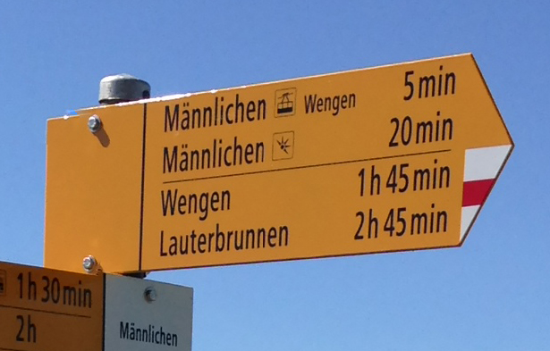 Whereas in the U.S. you would encounter a trailhead sign saying, Such-and-Such Peak: 6.7 miles, in Switzerland the equivalent would simply say 6 hours or even, possibly, 6 hours 25 minutes. Sort of charming, but I give this method a thumbs down. First, you can’t help but wonder how the trail-marker makers arrived at a given number. Was it based on the estimation of one opinionated Swiss mountain man? Was it based on a statistically significant random sample of hikers? Was it just a gut feeling? This matters because you need to trust that the number is meaningful. Moreover, you can’t help but compare your own time to the time on the sign. Am I doing better? Worse? If I take a ten minute break, will that throw off the count? Why am I thinking about this nonsense, anyway, when I’d rather just go for a hike? Just tell me how long the trail is and let me be the judge of how long I should take based on the difficulty of the terrain.
Restaurants and bars in the middle of nowhere
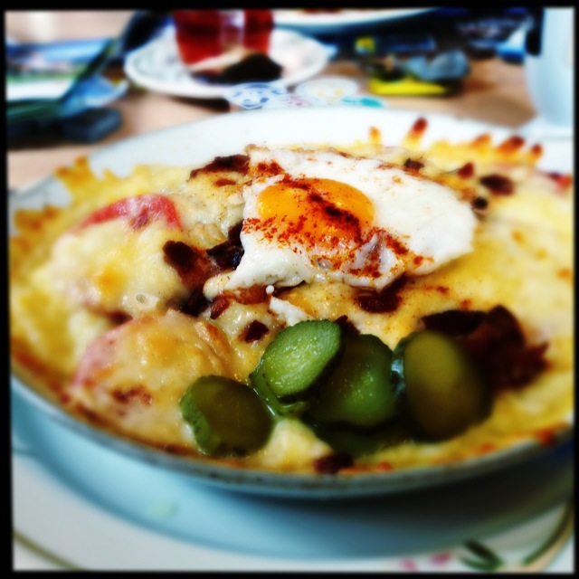
Wine soaked bread topped with cheese, bacon, roasted potatoes, and an egg. Served at a hikers’ hut.
On Saturday, we took advantage of a cool, sunny day to hike the celebrated route from Schynega Platte to First. A narrow gauge train delivered us to a ridge overlooking the Interlaken Lakes, and from there we hiked on a trail through alpine meadows, over talus slopes, and along dangerously steep mountainsides. After about 3 hours (who knows how many miles — see above), we arrived at a high pass, all rock and snow, cold wind, imposing summits to the right and left. And there, situated right in this narrow pass, was a restaurant. We’d brought a picnic, but still. If we’d been in the mood, we could have paused for fondue and rösti and beer. How did they get it all up there? There wasn’t a road, there wasn’t a gondola… Helicopter? Anyway, as long as you aren’t hoping to get out into true wilderness (if you are, probably don’t choose Switzerland), finding a restaurant in the middle of a long hike is pretty great. Thumbs up!
Quality maps not readily available
Wengen is a lovely Alpine village that draws throngs of outdoors enthusiasts, hikers, mountaineers. So I was surprised that the best available maps — at the outdoor store, the information center, the bookshop — were little more than illustrated ski guides, the kind that show a pretty illustration of a mountain with thick lines indicating various trails. On the surface, these seemed adequate. They displayed a variety of numbered trails, each number corresponding to a brief description on the flip side of the map. But the numbers didn’t correspond to trail signs in the real world. That is, if you decided to hike Trail 36 to Alpiglen, you could go to the spot where the map indicated Trail 36 seemed to begin, but all you’d see would be signs pointing to various places other than Alpiglen. Or there might be two or three signs, all of them pointing in different directions and all claiming to lead to Alpiglen. No mention of #36 to be found. (Shaking fist in air) Switzerland! Suggestion: if a trail is numbered on the map, have it numbered on the trail. Otherwise, just use the trail name. Otherwise, get the Swiss version of the U.S. Geological Survey to create topo maps with contour lines of the Jungfrau region and sell those maps in local stores.
Dogs
I think dogs are great, so thumbs up to Switzerland for being so accommodating. You see them on trails, in gondolas, sitting beside restaurant tables. Although… we did see one couple hiking with four annoying little yappers who chased marmots and disturbed the alpine flora, so they aren’t always so great. But we also saw an older couple with a big, friendly St. Bernard all wet from the trail who sat down on the floor of the restaurant where we were all eating lunch. Nobody minded. As the signs on the doggy-bag dispensers in Wengen say, “Bravo.”
Plenty more pictures of our time in Wengen here. Also, checkout our photo tumblr.
